 Location: Phut Ta Sathan Phu Singh, Sahasakhan district, far from Kalasin town in the north around 34 km.
How to go: From Kalasin town, you can use highway 227, there are 2 ways to get to summit Phu Singh; from east, it is a dirt sideroad that is pretty steep, so you should be careful or you can choose walk to the summit from west way, it have around 400steps from down to top hill.
Season: Rainy-Winter
The scenery and sample place of Phu Singh, Kalasin Province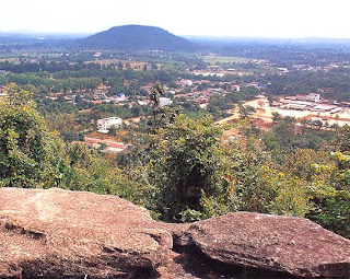
You can see the scenery of Sahasakhan district and Phu Kum Khao, which located another side from Phu Singh.
 Location: Phu Phrabard Historical National Park, far from Udon Thani town around 67km.
How to go: From Udon Thani town, take highway 2 (Udon Thani-Nong Khai) until reaching km marker 13, there turn right around 500m, go straight on highway 2348 for 12km and turn right to Phu.
Phrabard historical national pake office for 2km.
Season: All year, especially winter is most.
The scenery and sample place of Phu Phrabard, Udon Thani Province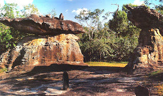
The story of stone art told about local story at Phu Prabard.
 Location: Phu Kao-Phu Phan Kham National Park, nearly Ubolratana Dam, far from Khon Kaen town for 56km.
How to go: From Khon Kaen town, you can use highway 2 (Khon Kaen-Udon Thani) for 26km, Turn left into highway 2109 for 24km to Ubonrat district, there are right turn into highway 2146 around 6km, got to Phu Kao-Phu Pan Khem national park office.
Season: Wintertime
The scenery and sample place of Phu Kao-Phu Phan Kham, Khon Kaen Province
Chong Khao Khad spot, it is one of the most brilliant beauty spot of Phu Pan Kham range.
The fish traps a canal derived from the benevolent Ubolratana Dam.
The scenery of Pha Maleuk Keukkak spot is most beautiful spot view point of Phu Kao-Phu Pan Kham National Park.
 Location: Within north of Pha Taem National Park, Sam Rong sub-district, Pho Sai district, far from Pha Taem National Park for 50km and far from Ubon Ratchathani town for 130km.
How to go: From Ubon Ratchathani town, take highway 2050 (Ubon Ratchathani-Khemarat) until Pho Sai district, you will turn into 2112 around the km marker 63, head on national park office.
Season: Late rainy season up to winter.
The scenery and sample place of Phu Samui, Ubon Ratchathani Province 
Sao Chaliang Yai, the most big of Pha Taem national park.
Small flower fields are blooming nicely on the top of Phu Samui.
Pha Nok Hoh spot, which located the west of Phu Samui. From here, you can watching the beautiful sunrise in mist in the wintertime too.
 Location: Phu Sra Dokbua National Park, Don Tan district, far from Mukdahan town around 60km.
How to go: From Mukdahan town, take highway 2034 (Mukdahan-Don Tan) until Don Tan district, you will turn right into highway 2277, you will find national park office, which located at km marker 24-25, far from Don Tan district for 22km.
Season: Late rainy season up to early winter
The scenery and sample place of Phu Sra Dokbua, Mukdahan Province
The scenery of Pha Ma Klue spot. Below are green rice fields of Don Tan district.
The grassland of Pa Phek and dwarf hill evergreen forest found in lsan’s rocky mountains.
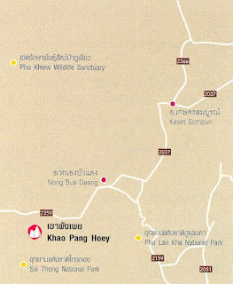 Location: Pa Hin Ngam National Park, Thep Sathit District and Sai Thong National Park, Nhong Bua Rahweh distrct, Chaiyaphoum.
How to go: From Bangkok, go along highway 1 through Saraburi on to Ban Phu-Khae and take a right into highway 21 until Chaibadan district, then take highway 205 pass Lamsonthi sub-district about 1 km before reach Thep Sathit district, turn left into 2354 for 17km.
Then turn left for 13km, you will find Pa Hin Ngam national park office.
So if you wish to get to Sai Thong National Park, you will take highway 2354 for 63km to Na Yang Klak, then turn left into Sab Mongkon where highway 225 is found turn right and go straight about 13km, you will find Sai Thong national park office.
Season: Rainy-Winter
The scenery and sample place of Khao Pang Hoey, Chaiyaphum Province
The beautiful scenery of Dok Kra Chiew or Dok Bua Sawan fields at Khao Pang Hoey, Sai Thong National Park.
 Location: Phu Lan Kha National Park, far from Chaiyaphum town around 32km.
How to go: From Chaiyaphum town, take highway 2051 (Chaiyaphum-Tad Ton) around 6km.
There are left turn into highway 2159 (Chaiyaphum-Nong Bua Deang) until km marker 26.
Then turn left to national park office.
Season: Rainy-Winter
The scenery and sample place of Mo Hin Khao, Chaiyaphum Province
Mo Hin Khao or Stone hade of Thailand the tourist attraction of Phu Land Kha National Park .
 Location: Khao Phra Wihan National Park, Kantoralak district, far from Si Sakat town around 98km.
How to go: From Si Sakat town,you can use highway 221(Si Sakat-Kantoralak) pass Kantoralak diatrict to the south for 36km, the direction to Khao Phra Wihan.
Season: Wintertime
The scenery and sample place of Pha Mo E-Daeng, Si Saket Province
Pha Mo E-Daeng spot, which located before get to Khao Phra Wihan. Below are historical painting the cliff.
 Location: Pha Taem National Park, Khong Chiam district, far from Ubon Ratchathani town for 100km.
How to go: From Ubon Ratchathani town, take highway 217 to Pi Boon Mang Sahan, then turn into highway 2222 to Khong Chiam district for 80 km.
Then turn left into highway 2112 for 15km, you will turn right about 5km at small junction to national park office.
Season: Late rainy season up to winter
The scenery and sample place of Phu Pha Taem, Ubon Ratchathani Province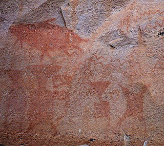
Historical wall painting on the cliff at Pha Taem.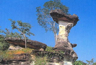
Sao Chaliang Noi along the way before get to Pha Taem national park office.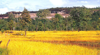
The scenery of Pha Taem. When you see from the green rice fields of Khong Chiem district, you can see the scenery of the cliff for long.
The scenery of Pha Taem spot, you can see Khong river and forests in the rainytime.


